VOLCÁN PACAYA OVER THE YEARS
 Highly active Pacaya Volcano is the most frequently climbed volcano in
Guatemala. It is relatively easily accessible and commonly puts on a good
show for volcano enthusiasts. The paragraphs and accompanying photos on this
webpage will give you an introduction to the volcano, its many types of
activity over the years 1970-2001, and hints on how to visit it safely.
Pacaya's current active phase began in 1965, and the volcano has been almost
constantly in eruption since then. Eruptive activity ranges from minor gaseous
emissions and quiet steam eruptions, to explosions powerful enough to hurl bombs
up to 12 kilometers and necessitate the evacuation of numerous villages on the
flanks of the volcano. Eruptions also include strombolian activity such as
shown above, vulcanian explosions, minor flows from the crater, and larger
flows emitted as flank eruptions.
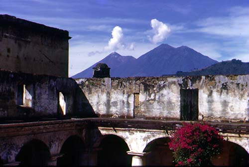
Pacaya is the active vent in the Cerro Grande-Pacaya-Cerro Chino volcanic
complex. It sits at the south end of the Guatemala City graben, a
down-dropped fault block that forms the north-south valley in which Guatemala
City lies. The volcanic complex may be related to the normal fault system
defining the east side of the graben. Here smoking
Pacaya is viewed from the highway to Antigua, which climbs the western
graben wall. Photographed 8/86.
Immediately to the north of the complex lies Lake Amatitlán, occupying
part of a caldera collapse structure. A small part of the lake can be made
out along the lower edge of this photo, Pacaya from
the air, taken 11/72, with the volcanic complex dominating the skyline.
The easiest and most secure way to visit Pacaya is to go with a licensed tour
operator, of which there are numerous in Antigua taking groups to visit Pacaya
every day for around $15 per person. Not a bad deal. Of all these operators,
we recommend most highly Sergio Garcia of Eco-Tour Chejo's (contact
information at the end of this webpage).
Or, if you have your own transportation and an adventurous spirit, you can go
on your own. To reach Pacaya, head south from Guatemala City, on the highway
to Esquintla, but turn off on the road to the town of San Vicente Pacaya and
Pacaya Volcano National Park before reaching the town of Palín. Watch
carefully for the sign...it's not very prominent.
The road up the mountain to San Vicente was paved in 2001. But from where the
entrada to San Vicente forks off down to the left the road continuing
straight on up through the village of Cedros to the hamlet of San Francisco de
Sales and Pacaya Volcano is dirt. It is rough, but passable all year round,
unless blocked by a landslide or mudflow.
There are two trails up Pacaya Volcano. The more gentle trail, followed by
most of the tour groups from Antigua, starts at San Francisco de Sales. Here
is the official entrance to the park, and where you need to stop to pay
admission (Q25 for foreign visitors in 2001). The trail from here is well
maintained, with rest stops, trash receptacles and restrooms (primitive), and
is patrolled by guardabosques (rangers). There is safe parking for your
vehicle here in San Francisco, and you can also buy refreshments here, which
are highly appreciated when you get back.
The second trail, which starts from the complex of radio towers on the flank
of Cerro Chino, is a bit tougher, but perhaps more rewarding for geology and
photogenic views. This is the trail described in this website. If you decide
to follow this trail, you should still check in at the park headquarters in
San Francisco de Sales and pay your admission. You should also be aware that
this trip is not patrolled by the guardabosques; there have been some
robberies on this trail in past years, and cars parked below the radio towers
have been broken into. If you choose this trail, you should hire a local kid
to watch your car while you are gone.
To hike this trail, pay your admission in San Francisco, then drive back down
the road to the first left hand fork. This takes you to the base of the steep
climb up to the radio towers. Most non-4WD vehicles can't make this climb
because the ash on the road is so loose, so plan to park down below at about
1895 m (6215 ft), leave your car with a boy to watch it, and hike on up the
road to the radio tower cluster. When you run out of road you're not far from
the ridgecrest, so just follow an uphill trail and keep on huffin' and puffin'
your way up the steep climb to pop out on the rim of the old Cerro Chino
crater, at about 2265 m (7430 ft). Here you have a good place to take a rest
break and a terrific view of Pacaya cone.
Photo 8/86.
The trail continues to the left along this rim, gradually climbing and circling
around to the base of the Pacaya cone. Along the way a geologic cross-section, can be seen in the cliffs below the Cerro
Chino rim, revealing the interlayering of flows and pyroclastic deposits
characteristic of a composite volcano. In the photo taken 6/89, the flows
show up as lighter layers, and the ashy pyroclastic deposits as darker layers.
A dike can be seen in the center of the photo, cutting diagonally across the
layers.
Below the rim trail, the ancient Cerro Chino crater is partially filled with recent flows, such as seen in this 3/78 photo.
Note that at this time, Pacaya was in a quiet steam eruption. On the flows
below the Cerro Chino rim, if your screen image is large enough, you may see
a tiny light blue spot on a flow lobe in the lower center part of this shot;
that's a geology major from Tennessee Technological University, to give you a
scale. In this 8/92 telephoto shot, a flow with
pressure ridges and lava levees can be seen.
As you continue around the Cerro Chino rim, the main trail from the park
entrance joins from the left. You will see an information sign near this trail
junction.
The rim trail brings you to the base of Pacaya's cone, where the final steep ascent begins. This 8/92 photo looks
down on the end of the rim trail. The final climb
is only about 150 m (500 ft), but is a real huffer-puffer. With each step in
the loose ash and scoria you gain a bit, and slide back a bit.
Just before reaching the summit, the trail turns back to the left towards
the old summit. To the right is the currently active vent. If there is
any explosive activity, it is best to continue to the old peak first. After
observing the activity from the old peak for a while a judgment can be made
as to whether or not you want to approach the active vent.
The published elevation is 2560 m (8400 ft), but of course it varies from year
to year, according to the building and destroying volcanic processes. The view from the peak is magnificent! At the time
of this 11/70 shot you could look down on the active vent, which blew off in
small steam explosions, throwing small bombs straight up into the air perhaps
100 m. To the northwest, the soaring cone of the extinct stratovolcano Agua
(3760 m/12,335 ft) can be seen. Beyond Agua is the double cone of Volcanes
Fuego and Acatenango, partially covered by clouds. Fuego (3763 m/12,345 ft),
on the left, is historically the most active and dangerous of the major cones
in Guatemala. Acatenango (3975 m/13,040 ft) still has some active fumaroles
at its peak and is certainly not extinct yet.
In March 1978, the old crater still existed,
but was in the process of being destroyed. The photo shows a small bluff line
running across the righthand wall of crater: this is a fault scarp. In 1978,
most of the old summit crater was bit-by-bit slipping down towards the new
vent.
The cone that has been built up, destroyed, and rebuilt several times since
1965 is known as the McKenney Cone, after Dr. Alfredo McKenney, of Guatemala
City. Don Alfredo has climbed the volcano literally hundreds of times, and
has compiled a magnificent photographic record of the modern phase of activity
at Pacaya. In August 1986, activity at the McKenney cone crater consisted
of spatter cones sporadically lobbing small
blobs of molten lava into view. In January 1987 a powerful explosion hurled
boulders and bombs up to 12 km, damaging homes in nearby villages. In June
1987, small flows were streaming down the
flank of the cone; the alignment of the flows indicates that they were
issuing from a fissure.
In June 1988 the active vent was higher and larger than in August '86, with
small-scale vulcanian activity sending up
roiling ashy clouds, and making "chuffing" noises. The cone was approachable,
but not with total safety; in this photo, the person descending from the rim
of the cone is doing so in haste, fleeing the rain of ash and hot rocks from
an unexpectly strong "chuff".
In addition to the possibility of being hit by a falling bomb during explosive
eruptions, visitors to the rim must also be cautious about volcanic gases.
Here yellow sulfur sublimates on the rim trail
attest to the sulfurous gases pouring over the crater rim. When inhaled,
sulfur dioxide combines with water in the lungs to form sulfuric acid. The
burning sensation is very unpleasant, and high doses could be harmful.
Becoming trapped in a cloud of sulfurous gases could be fatal. It is best to
stay on the up-wind side of the vent, where you can drop down below the rim
when blasts of sulfurous gases swirl your way. Also, keep an eye out for a
quick retreat route if the wind direction shifts and more than just a
momentary swirl of noxious gases heads your way.
By June 1989 the previous year's summit cone had collapsed, and a double crater in the shape of a figure-8 had
taken its place. The white clouds are steam, but near the right edge of the
photo a bluish cloud can be seen, which is sulfurous and to be avoided. Within
the nearer of the twin craters rose a bizarre chimney of congealed lava. This double crater still existed in
March 1990, but the near crater had become largely filled in. Nonetheless, it
was still the site of small explosive
activity, and a real fun show.
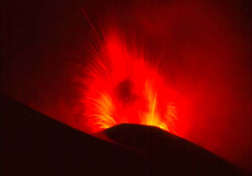
Of course, strombolian explosions are most spectacular when viewed at night,
as shown in this shot of volcanic fireworks
taken from the Cerro Chino rim, May 1994. The opening photo for this page was taken at the same time.
What goes up, like volcanic bombs, must come down. And the same is true of
volcano watchers. The safe way back down from the peak is to follow the
same trail used to ascend. But the fun way is to "ash ski" down the straight shot trail from the old summit, as these
volcano fans were doing in Aug. 1996. But have a care! A tumble on this
slope would result in multiple abrasions, if not in broken bones.
Highly active Pacaya Volcano is the most frequently climbed volcano in
Guatemala. It is relatively easily accessible and commonly puts on a good
show for volcano enthusiasts. The paragraphs and accompanying photos on this
webpage will give you an introduction to the volcano, its many types of
activity over the years 1970-2001, and hints on how to visit it safely.
Pacaya's current active phase began in 1965, and the volcano has been almost
constantly in eruption since then. Eruptive activity ranges from minor gaseous
emissions and quiet steam eruptions, to explosions powerful enough to hurl bombs
up to 12 kilometers and necessitate the evacuation of numerous villages on the
flanks of the volcano. Eruptions also include strombolian activity such as
shown above, vulcanian explosions, minor flows from the crater, and larger
flows emitted as flank eruptions.
Pacaya is the active vent in the Cerro Grande-Pacaya-Cerro Chino volcanic
complex. It sits at the south end of the Guatemala City graben, a
down-dropped fault block that forms the north-south valley in which Guatemala
City lies. The volcanic complex may be related to the normal fault system
defining the east side of the graben. Here smoking
Pacaya is viewed from the highway to Antigua, which climbs the western
graben wall. Photographed 8/86.
Immediately to the north of the complex lies Lake Amatitlán, occupying
part of a caldera collapse structure. A small part of the lake can be made
out along the lower edge of this photo, Pacaya from
the air, taken 11/72, with the volcanic complex dominating the skyline.
The easiest and most secure way to visit Pacaya is to go with a licensed tour
operator, of which there are numerous in Antigua taking groups to visit Pacaya
every day for around $15 per person. Not a bad deal. Of all these operators,
we recommend most highly Sergio Garcia of Eco-Tour Chejo's (contact
information at the end of this webpage).
Or, if you have your own transportation and an adventurous spirit, you can go
on your own. To reach Pacaya, head south from Guatemala City, on the highway
to Esquintla, but turn off on the road to the town of San Vicente Pacaya and
Pacaya Volcano National Park before reaching the town of Palín. Watch
carefully for the sign...it's not very prominent.
The road up the mountain to San Vicente was paved in 2001. But from where the
entrada to San Vicente forks off down to the left the road continuing
straight on up through the village of Cedros to the hamlet of San Francisco de
Sales and Pacaya Volcano is dirt. It is rough, but passable all year round,
unless blocked by a landslide or mudflow.
There are two trails up Pacaya Volcano. The more gentle trail, followed by
most of the tour groups from Antigua, starts at San Francisco de Sales. Here
is the official entrance to the park, and where you need to stop to pay
admission (Q25 for foreign visitors in 2001). The trail from here is well
maintained, with rest stops, trash receptacles and restrooms (primitive), and
is patrolled by guardabosques (rangers). There is safe parking for your
vehicle here in San Francisco, and you can also buy refreshments here, which
are highly appreciated when you get back.
The second trail, which starts from the complex of radio towers on the flank
of Cerro Chino, is a bit tougher, but perhaps more rewarding for geology and
photogenic views. This is the trail described in this website. If you decide
to follow this trail, you should still check in at the park headquarters in
San Francisco de Sales and pay your admission. You should also be aware that
this trip is not patrolled by the guardabosques; there have been some
robberies on this trail in past years, and cars parked below the radio towers
have been broken into. If you choose this trail, you should hire a local kid
to watch your car while you are gone.
To hike this trail, pay your admission in San Francisco, then drive back down
the road to the first left hand fork. This takes you to the base of the steep
climb up to the radio towers. Most non-4WD vehicles can't make this climb
because the ash on the road is so loose, so plan to park down below at about
1895 m (6215 ft), leave your car with a boy to watch it, and hike on up the
road to the radio tower cluster. When you run out of road you're not far from
the ridgecrest, so just follow an uphill trail and keep on huffin' and puffin'
your way up the steep climb to pop out on the rim of the old Cerro Chino
crater, at about 2265 m (7430 ft). Here you have a good place to take a rest
break and a terrific view of Pacaya cone.
Photo 8/86.
The trail continues to the left along this rim, gradually climbing and circling
around to the base of the Pacaya cone. Along the way a geologic cross-section, can be seen in the cliffs below the Cerro
Chino rim, revealing the interlayering of flows and pyroclastic deposits
characteristic of a composite volcano. In the photo taken 6/89, the flows
show up as lighter layers, and the ashy pyroclastic deposits as darker layers.
A dike can be seen in the center of the photo, cutting diagonally across the
layers.
Below the rim trail, the ancient Cerro Chino crater is partially filled with recent flows, such as seen in this 3/78 photo.
Note that at this time, Pacaya was in a quiet steam eruption. On the flows
below the Cerro Chino rim, if your screen image is large enough, you may see
a tiny light blue spot on a flow lobe in the lower center part of this shot;
that's a geology major from Tennessee Technological University, to give you a
scale. In this 8/92 telephoto shot, a flow with
pressure ridges and lava levees can be seen.
As you continue around the Cerro Chino rim, the main trail from the park
entrance joins from the left. You will see an information sign near this trail
junction.
The rim trail brings you to the base of Pacaya's cone, where the final steep ascent begins. This 8/92 photo looks
down on the end of the rim trail. The final climb
is only about 150 m (500 ft), but is a real huffer-puffer. With each step in
the loose ash and scoria you gain a bit, and slide back a bit.
Just before reaching the summit, the trail turns back to the left towards
the old summit. To the right is the currently active vent. If there is
any explosive activity, it is best to continue to the old peak first. After
observing the activity from the old peak for a while a judgment can be made
as to whether or not you want to approach the active vent.
The published elevation is 2560 m (8400 ft), but of course it varies from year
to year, according to the building and destroying volcanic processes. The view from the peak is magnificent! At the time
of this 11/70 shot you could look down on the active vent, which blew off in
small steam explosions, throwing small bombs straight up into the air perhaps
100 m. To the northwest, the soaring cone of the extinct stratovolcano Agua
(3760 m/12,335 ft) can be seen. Beyond Agua is the double cone of Volcanes
Fuego and Acatenango, partially covered by clouds. Fuego (3763 m/12,345 ft),
on the left, is historically the most active and dangerous of the major cones
in Guatemala. Acatenango (3975 m/13,040 ft) still has some active fumaroles
at its peak and is certainly not extinct yet.
In March 1978, the old crater still existed,
but was in the process of being destroyed. The photo shows a small bluff line
running across the righthand wall of crater: this is a fault scarp. In 1978,
most of the old summit crater was bit-by-bit slipping down towards the new
vent.
The cone that has been built up, destroyed, and rebuilt several times since
1965 is known as the McKenney Cone, after Dr. Alfredo McKenney, of Guatemala
City. Don Alfredo has climbed the volcano literally hundreds of times, and
has compiled a magnificent photographic record of the modern phase of activity
at Pacaya. In August 1986, activity at the McKenney cone crater consisted
of spatter cones sporadically lobbing small
blobs of molten lava into view. In January 1987 a powerful explosion hurled
boulders and bombs up to 12 km, damaging homes in nearby villages. In June
1987, small flows were streaming down the
flank of the cone; the alignment of the flows indicates that they were
issuing from a fissure.
In June 1988 the active vent was higher and larger than in August '86, with
small-scale vulcanian activity sending up
roiling ashy clouds, and making "chuffing" noises. The cone was approachable,
but not with total safety; in this photo, the person descending from the rim
of the cone is doing so in haste, fleeing the rain of ash and hot rocks from
an unexpectly strong "chuff".
In addition to the possibility of being hit by a falling bomb during explosive
eruptions, visitors to the rim must also be cautious about volcanic gases.
Here yellow sulfur sublimates on the rim trail
attest to the sulfurous gases pouring over the crater rim. When inhaled,
sulfur dioxide combines with water in the lungs to form sulfuric acid. The
burning sensation is very unpleasant, and high doses could be harmful.
Becoming trapped in a cloud of sulfurous gases could be fatal. It is best to
stay on the up-wind side of the vent, where you can drop down below the rim
when blasts of sulfurous gases swirl your way. Also, keep an eye out for a
quick retreat route if the wind direction shifts and more than just a
momentary swirl of noxious gases heads your way.
By June 1989 the previous year's summit cone had collapsed, and a double crater in the shape of a figure-8 had
taken its place. The white clouds are steam, but near the right edge of the
photo a bluish cloud can be seen, which is sulfurous and to be avoided. Within
the nearer of the twin craters rose a bizarre chimney of congealed lava. This double crater still existed in
March 1990, but the near crater had become largely filled in. Nonetheless, it
was still the site of small explosive
activity, and a real fun show.
Of course, strombolian explosions are most spectacular when viewed at night,
as shown in this shot of volcanic fireworks
taken from the Cerro Chino rim, May 1994. The opening photo for this page was taken at the same time.
What goes up, like volcanic bombs, must come down. And the same is true of
volcano watchers. The safe way back down from the peak is to follow the
same trail used to ascend. But the fun way is to "ash ski" down the straight shot trail from the old summit, as these
volcano fans were doing in Aug. 1996. But have a care! A tumble on this
slope would result in multiple abrasions, if not in broken bones.
If you plan to climb Pacaya, you need to allow all day for the trip. The climb
up generally takes 2-3 hours. It is non-technical, but tiring and you'll feel
the elevation. The weather is generally better in the morning than in the
afternoon when clouds and rain are more likely. However, if the volcano is in
a phase of strombolian eruptions or active flows, nighttime views can be
incredible. You need good advance information, and you should go with a guide,
for safety reasons explained below.
If you are not traveling with an organized tour out of Antigua, you should
definitely hire a local guide to accompany you. And no vehicle should be left
unguarded. There have been incidents of robbery and assault on the mountain
over the years, and parked vehicles have been looted. It may not be safe to
climb the volcano independently. Information as to current volcanic activity
and any recent security problems on Pacaya can be obtained from the INGUAT
office on the Plaza de Armas in Antigua and from various tour agencies
in Antigua offering trips to Pacaya.
What you need for the hike: Good boots that lace up (low cut shoes and tennis
shoes fail to provide ankle support and also let volcanic grit get into your
socks, which can be pretty uncomfortable); canteen of water; snacks;
sunblock and dark glasses; a hat that won't blow off (one with a chin strap
would be good); rain poncho just in case of bad weather; jacket and long
pants if you plan to be on the mountain at night; camera and film; maybe
about Q50-- Q25 for the park entrance fee and little extra for refreshments
when you get back down. It is not recommended that you bring unnecessary cash,
jewelry, expensive watches (windblown volcanic grit can be hard on watches).
PACAYA UPDATE, June, 2001: Volcán Pacaya has been made a national park.
A visitor's center/ticket booth has been constructed at San Francisco de
Sales and is being provided with displays; there are restrooms here. A nice
trail to the volcano has been opened, complete with rest areas, trash bins, and
directional signs. There are even restrooms at one spot. And rangers have
been hired to ensure visitor security. At the present time Pacaya seems free
of the robberies and troubles of the past. Nonetheless, it is still
recommended that visitors go with a guide.
We recommend Sergio Garcia as a Pacaya guide par excellence. Sergio has
a passion for Pacaya, having climbed the mountain over 1900 times (as of June
2001). He knows every nuance of the mountain and regularly leads groups up
to see the action. Contact Sergio at Eco-Tour Chejo's in Antigua Guatemala.
Address: 3a. Calle Poniente, No. 24; phones 832-5605 and 832-2657.
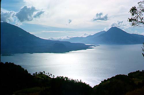
WOULD YOU LIKE TO CLIMB PACAYA AS JUST ONE OF MANY HIGH POINTS IN A
SPECTACULAR GUATEMALA EXCURSION? If so, visit our homepage: Rutahsa Adventures to find out what amazing
Guatemala trips we are currently offering. Most of our Guatemala excursions
include a Pacaya climb, and all feature glorious views of the gigantic soaring
cones of Agua, steaming Fuego with its twin,
Acatenango dominating the skyline of Antigua, and Tolimán,
Atitlán, and San Pedro towering over beautiful Lake Atitlán. We sometimes visit the dramatic Santiaguito explosion crater, and the sacred
crater lake at the extinct Chicabal volcano.
Each trip is different, but all are enhanced by the majesty of Guatemala's
volcanoes.
Return to beginning of Pacaya page.
Comments and enquiries can be sent to: rfinch@graterutabaga.com.
Photos on this website by Janie and Ric Finch, @copyrighted.